The Territorial Diagnostic
Understanding food systems to transform territories
Before acting, we must understand. The territorial food system diagnostic is the foundational tool of CREATES' territorial approach. Through the DyTAEL platforms (Dynamiques Territoriales pour l'Agroécologie Locale), we produce a systemic reading of territories that combines spatial data, field surveys, local knowledge and institutional analysis. This diagnostic is not an academic exercise: it is a shared governance tool, co-constructed with the actors of the territory.
DyTAEL: inclusive territorial governance
The DyTAEL are multi-stakeholder platforms that bring together producers, processors, traders, local elected officials, researchers and civil society organisations around a common goal: building territorial food systems that are ecological, just and resilient. Each DyTAEL is rooted in a specific territory — Mbour, Bignona, and soon others — and functions as a space for diagnosis, dialogue and collective action. It is within these platforms that territorial diagnostics, transformative scenarisation workshops and shared decisions about the territory's food future take place.
A participatory and systemic methodology
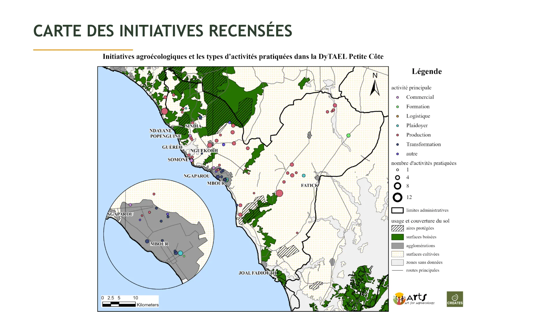
The territorial diagnostic employs a mixed and participatory methodology. In the department of Mbour, 64 agroecological initiatives were visited, 20 of which were the subject of in-depth case studies. Three participatory mapping workshops were organised, complemented by two village-level case studies and one transformative scenarisation workshop. The analysis draws on seven axes of the SAAT framework (Territorial Food Systems and Agroecology), combining interviews, document review, spatial and statistical analysis, and forum theatre. This approach captures the complexity of the territory across its ecological, economic, social and political dimensions.
The Petite Côte: a territory under pressure
The DyTAEL Mbour diagnostic reveals a territory in accelerated transformation. With 935,000 inhabitants and demographic growth of 40% in ten years, the department of Mbour is one of the most dynamic in Senegal. But this growth comes at a cost: 10,783 hectares of natural spaces lost in a decade, savannas reduced by 87.5%, steppes by 31%, urbanised surfaces up by 48.7%. Everything that advances is linked to artificialisation; everything that retreats is natural space. The territory is caught between the peri-urbanisation of Dakar, export-oriented agribusiness, extractive industries and mega-infrastructure projects.

Multiple pressures on the territory
The diagnostic highlights converging pressures. Agribusiness has expanded irrigated surfaces from 1,144 to 4,358 hectares (+280%), with around thirty farms of 50 to 400 hectares oriented towards export, depleting aquifers with no local food benefit. Water pumping volumes in Mbour have increased tenfold, causing aquifer collapse — the Maastrichtian could drop to -80 m by 2050. Extractive industries (limestone, basalt, laterite, sand) supply 84% of the country's construction materials, but environmental costs remain on the territory. Classified forests, meant to protect the commons, are being converted: 49.6% of Bandia forest is encroached by mines and agribusiness. And mega-projects — Ndayane port, the new city of Daga Kholpa, special economic zones — are accelerating land speculation without integrating the food dimension.
Actors of the agroecological transition
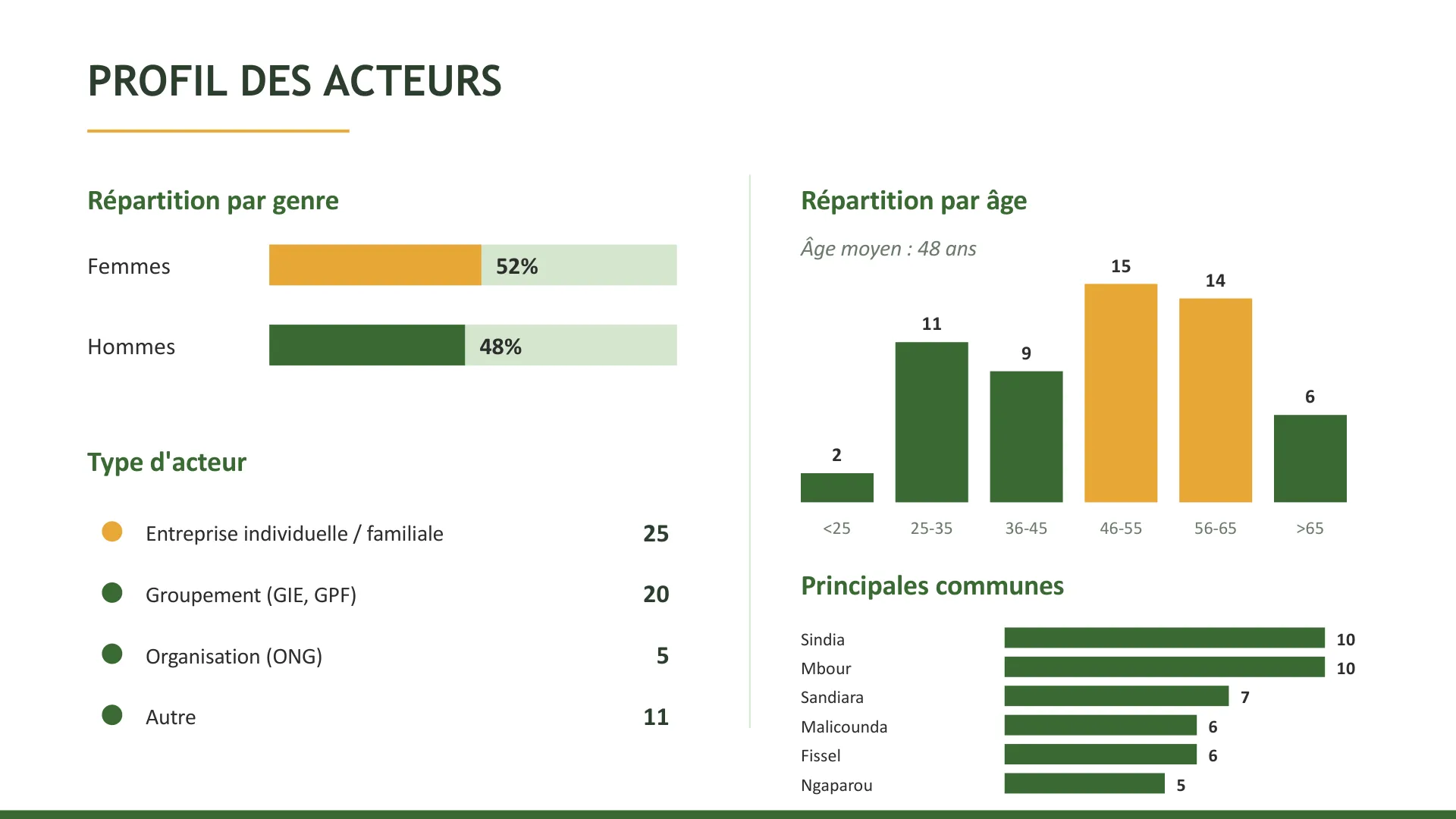
In the face of these pressures, the diagnostic identifies over 64 active agroecological initiatives in the territory, 52% led by women. These actors practise crop rotation, organic fertilisation, agroforestry, rational water management and the use of local varieties. They operate across the entire value chain: production, processing, marketing, training and collective action. But they express critical needs: financing (44%), training (36%), technical support (32%), water access (24%). Their motivations are clear: preserving the environment and biodiversity (46%), producing healthy food (41%), rejecting chemical products (25%).
The Agroecology Atlas: making the transition visible
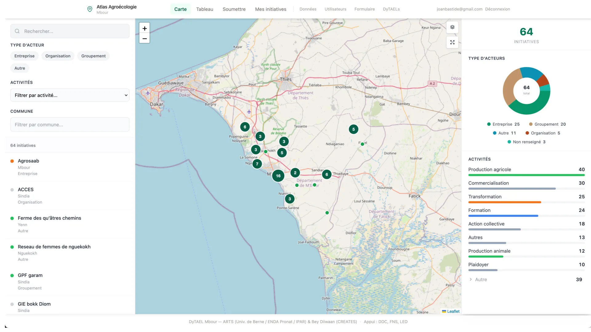
To give cartographic visibility to the actors of the agroecological transition, CREATES developed the Agroecology Atlas (atlas.creates.ngo), an interactive platform that allows users to visualise, filter and explore initiatives by actor type, activity and municipality. The atlas operates at two scales: the national DyTAES view (Dynamics for Agroecology in Senegal) and the territorial DyTAEL views (Mbour, Bignona). Actors themselves can submit their initiatives, making the atlas a living tool for networking and advocacy. It is a key instrument of the territorial diagnostic: it makes visible those who act and enables thinking about complementarities and synergies at the territorial scale.
A territory of opportunity
Despite the pressures, the diagnostic reveals a territory full of opportunity. The Dakar-Thiès-Mbour triangle concentrates 29% of national food demand on 2% of the territory — a considerable market for short supply chains. Women are at the heart of the food system, urban demand for quality local products is growing steadily, and remarkable ecosystems (Somone, Bandia, Joal) offer ecotourism potential. The DyTAEL already federates over 60 agroecological actors, and a territorial Participatory Guarantee System is being prepared. The territory has everything to feed its inhabitants. What it lacks is a food strategy — and that is precisely what the territorial diagnostic enables.